
Madeira is the summit of a shield volcano that rose from the Atlantic some five million years ago, roughly 1,000 km southwest of Lisbon and closer to Morocco than to mainland Portugal. Portuguese sailors claimed it for Prince Henry the Navigator in 1419, and the island they found was so thickly wooded that they simply called it madeira — timber. Six centuries on, it is a place of 1,800-metre peaks poking through the cloud, terraced vineyards, banana groves, sea cliffs and a laurel forest older than the settlement itself.
It is also an island best understood through its stories: why the farmers' market in Funchal looks like a 1940s state monument, how a 15th-century irrigation scheme became Europe's most beloved hiking network, why gentlemen in straw boaters still steer wicker sledges down a mountain road. Each landmark here has its own self-guided audio guide, so you can walk the old town, ride the cable car or follow a levada and hear that story as the view opens up in front of you. Start with the Zona Histórica do Funchal, the cobbled quarter where the whole island began.

Funchal: the old town, the market and the cathedral
Funchal, the capital, is home to roughly 100,000 of the archipelago's 250,000 people and climbs the hillside in an amphitheatre around its bay. The Mercado dos Lavradores opened in 1940 in the monumental style of the Estado Novo regime; its tiled façade and flower-sellers in striped folk costume are as much a sight as the passion fruit, custard apples and black scabbardfish on the stalls inside. A few streets away, Funchal Cathedral (the Sé) is one of the oldest buildings on the island, finished in the early 1500s with a cedar ceiling in Moorish-influenced style, while the yellow-walled Forte de São Tiago has guarded the seafront since the 17th century. The surrounding lanes of the Zona Velha are painted-door country by day and poncha-bar country by night.
Mercado dos Lavradores (farmers' market)
Art Deco market hall of tiled facades, tropical fruit stalls, flowers and a deep-sea fish hall.
Funchal Cathedral
Late Gothic cathedral with a carved island-cedar ceiling and a climbable clock tower over the sea.
Forte de São Tiago
Yellow seventeenth-century seafront fortress with bastions, ramparts and wide Atlantic views.
Up to Monte by cable car, down by wicker toboggan
The Teleférico do Funchal lifts you in about twenty minutes from the old town to the hillside parish of Monte, 560 metres above the harbour. Up here, the Jardim Monte Palace Madeira spreads oriental gardens, azulejo panels and koi ponds across a former hotel estate, and the church of Nossa Senhora do Monte holds the tomb of Charles I, the last Austrian emperor, who died in exile on the island in 1922. Then there is the descent. The Associação dos Carreiros do Monte runs the wicker toboggans that locals used as public transport from the early 19th century: two drivers in white, rubber-soled boots as brakes, two kilometres of steep asphalt at speeds that have been clocked near 40 km/h. The audio guide tells you the history before you climb in — the ride itself leaves no time to listen.
Teleférico do Funchal
Gondola lift climbing from the seafront old town to a hillside parish, with harbour and rooftop views.
Jardim Monte Palace Madeira
Hillside tropical garden with koi lakes, oriental gardens and a vast collection of tile panels.
Associação dos Carreiros do Monte
Wicker toboggans on greased wooden runners, steered downhill by white-clad drivers in rubber boots.
Pico do Arieiro to Pico Ruivo above the clouds
The island's spine is a line of volcanic peaks that regularly stand above a sea of cloud. Pico do Arieiro (1,818 m) is reachable by road and is the classic sunrise spot; from its summit the PR1 Vereda do Areeiro trail runs along knife-edge ridges and through hand-cut tunnels to Pico Ruivo, at 1,862 metres the highest point in Madeira. It is one of Europe's great mountain walks, around seven kilometres each way with serious ascents, so most people start early and watch the weather. The guides at each end explain how this landscape formed — the last eruptions were only about 6,500 years ago — and why the plants clinging to the rock exist nowhere else.
Pico do Arieiro
Rugged volcanic summit reached by road, with sunrise views above the clouds and ridge trails.
PR1 Vereda do Areeiro
Ridge trail linking the island's highest peaks through volcanic tunnels and cliff-edge walkways.
Pico Ruivo
Highest summit of the island, a bare rocky crown above the clouds reached by high ridge trails.
Levadas through the laurisilva
Madeira's north is wet and its south is dry, so from the 15th century settlers carved narrow stone channels — levadas — to carry water across the island. More than 2,000 kilometres of them were built, and their maintenance paths now make the best walking trails anywhere in the Atlantic. The PR6 25 Fontes hike & Levada do Risco above Rabaçal leads to a mossy amphitheatre fed by twenty-five springs and a veil of a waterfall; the Levada do Caldeirão Verde PR9 near Santana threads tunnels and cliff ledges to a green cauldron of a cascade. Both run through the laurisilva, the subtropical laurel forest that once covered southern Europe and has been a UNESCO World Heritage Site since 1999. For the forest at its most atmospheric, go to Fanal Forest on the Paul da Serra plateau, where ancient, wind-bent til trees stand in the fog like something from a fable.
PR6 25 Fontes hike & Levada do Risco
Cliff-cut irrigation channel through laurel forest to a spring-fed cascade and a tall waterfall.
Levada do Caldeirão Verde PR9
Cliffside irrigation channel through laurel forest and rock tunnels to a waterfall-fed green pool.
Fanal Forest
Misty upland pasture of centuries-old laurel trees, grazed by cattle and wrapped in drifting cloud.
Cabo Girão, Câmara de Lobos and a glass of Madeira
West of Funchal the coast road climbs to Cabo Girão, a sea cliff of around 580 metres with a glass-floored skywalk hanging over the terraced fajãs far below. In its shadow sits Câmara de Lobos, the fishing village where Winston Churchill set up his easel in 1950 and where the scabbardfish boats still come in under the cliffs; it is the home of poncha, the island's rum-and-citrus cocktail. Back in the capital, Blandy's Wine Lodge has been run by the same family for two centuries and walks you through the sugar-to-vineyards story of Madeira wine — the fortified wine that was heated in ships' holds on the way to the colonies and toasted at the signing of the American Declaration of Independence.
Cabo Girão
Towering sea cliff with a glass-floored skywalk above farmed terraces at the ocean's edge.
Câmara de Lobos
Working fishing harbour of painted double-bowed boats, famed for black scabbardfish and poncha.
Blandy's Wine Lodge
Historic Madeira wine lodge with oak-cask ageing rooms, cooperage, museum and tastings of rare vintages.
The wild north and the eastern tip
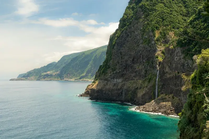
The north coast is a different island: basalt, surf and waterfalls that fall straight onto the road. At Piscinas Naturais do Porto Moniz, lava flows have cooled into natural seawater pools that the Atlantic refills with every wave. Inland at Santana, the triangular thatched palheiros — once family homes with the harvest stored in the loft — survive as the island's most photographed houses, in a municipality that UNESCO named a biosphere reserve in 2011. At the opposite end, Ponta de São Lourenço is Madeira stripped bare: a treeless volcanic peninsula of red and ochre rock, where a nature-reserve trail from Caniçal walks you out to the end of the island with the ocean on both sides.
Piscinas Naturais do Porto Moniz
Seawater pools set in black volcanic rock, refreshed by Atlantic waves and sheltered from the surf.
Santana
North-coast farming village of steep A-frame thatched cottages painted red, white and blue.
Ponta de São Lourenço
Rocky volcanic peninsula of basalt dykes and bare cliffs, ending at a lighthouse islet.
Getting around
Funchal is compact and walkable, and its cable car, buses and the toboggan cover Monte. For the peaks, the levadas and the north coast you will want a hire car or a tour; roads are excellent but steep, and the tunnels that now bore through the mountains have cut most cross-island journeys to under an hour. Weather changes by valley — sun in Funchal, cloud at Arieiro, rain in Santana — so check the summit webcams before you commit to a hike. The audio guides work offline on the trail, where signal does not.