

Christchurch is the largest city on New Zealand's South Island and the one that had to reinvent itself. Laid out by English settlers in the 1850s as a tidy Anglican town of stone colleges, a Gothic cathedral and a willow-lined river, it was torn apart by the earthquakes of 2010 and 2011 — and then rebuilt, block by block, into something more inventive than before. Today the flat, compact centre mixes surviving Victorian landmarks with a cathedral made of cardboard, a riverside food hall, street art and a new generation of public buildings, all within an easy walk of each other.
That layering makes it a city where the stories matter as much as the sights, and where a self-guided audio guide earns its keep. Stand in Cathedral Square and the scaffolded shell of ChristChurch Cathedral looks like a ruin; the audio guide tells you what the 1881 nave meant to the city, why the 2011 quake toppled its spire, and how a staged reinstatement — construction restarting in 2026, with the tower, nave and Rose Window targeted for reopening by 2030 — is meant to let the hoardings come down and the square come back to life.

Hagley Park and the Botanic Gardens
The green heart of the city is enormous. Hagley Park wraps around the Christchurch Botanic Gardens, 21 hectares of themed gardens, conservatories and specimen trees that began with a single English oak planted in 1863. The Avon River / Ōtākaro winds through it all, and the classic way to see it is from a flat-bottomed punt launched from the Antigua Boat Sheds: a thirty-minute glide beneath the willows while a punter in Edwardian dress points out the trees and birdlife. Listen to the audio guide first and you will know which oak is the founding one and why the Peace Bell is here.
Christchurch Botanic Gardens
Riverside botanic garden of heritage trees, rose beds, native plants and formal floral lawns.
Hagley Park North
Broad lawns and mature trees on ground that once held a vast, short-lived world's-fair hall.
Punting On The Avon (Antigua Boat Sheds)
Striped Victorian riverside boat shed still hiring rowboats, canoes and punts on a willow-lined river.
The Cardboard Cathedral and the earthquake story
A few minutes east of the square stands the city's most unlikely landmark. The Cardboard Cathedral, designed by Japanese architect Shigeru Ban and opened in August 2013, was raised from 86 giant cardboard tubes on a base of shipping containers as a temporary stand-in for the ruined cathedral; it has since become permanent and still fills with worshippers. Around the corner on the south bank of the Avon, the Canterbury Earthquake National Memorial (Oi Manawa) carves the names of the 185 people killed into a long marble wall, with trees and seating on the opposite bank. Quake City, the compact museum nearby, fills in the rest with survivor interviews and salvaged fragments. Each stop has its own guide, so you can hear the sequence of events as you walk between them.
Cardboard Cathedral
Transitional Anglican cathedral with an A-frame of giant cardboard tubes and stained-glass triangles.
Canterbury Earthquake National Memorial
Riverside marble wall bearing the names of those killed in the February 2011 earthquake.
Quake City
Earthquake museum holding the fallen cathedral spire tip, station clocks and relics of the 2011 quakes.
Museums along Worcester Boulevard
Worcester Boulevard runs from the square to the park, and the city's Victorian Gothic institutions line it. The Arts Centre Te Matatiki Toi Ora, once Canterbury College where Ernest Rutherford studied, is now a warren of galleries, cafés and cinemas in painstakingly restored stone. At the end of the boulevard the Canterbury Museum holds the skull of the extinct Haast's eagle and sledges from the Antarctic expeditions that sailed from here (its main building is mid-redevelopment, so part of the collection shows at 66 Gloucester Street until around 2029). Across the road, the glass curves of Christchurch Art Gallery Te Puna o Waiwhetū house the country's strongest collection of New Zealand art.
The Arts Centre Te Matatiki Toi Ora
Historic former university campus turned arts hub, with theatres, courtyards and a Great Hall.
Canterbury Museum
Gothic Revival natural-history museum founded on moa bones, now closed for a major rebuild.
Christchurch Art Gallery Te Puna o Waiwhetū
Public art museum behind a rippling glass façade, built over an artesian spring.
Riverside Market, New Regent Street and the tram
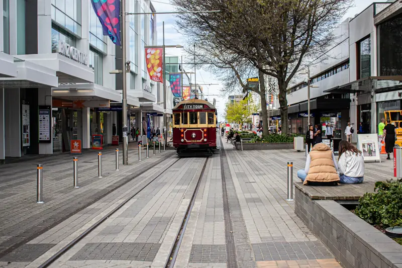
The rebuilt centre is best understood through its new gathering places. Riverside Market is the city's indoor food hall — fresh produce, bakers, bars and a dozen kitchens under one roof, with live music some evenings. New Regent Street, a pastel-coloured 1930s Spanish Mission row that survived the quakes, is where the heritage Christchurch Tram rattles through at walking pace; a day ticket lets you hop on and off around its 50-minute inner-city loop past the Bridge of Remembrance and the gardens.
Riverside Market
Seven-day indoor food market of local produce, butchery, bakery, fishmonger and street-food stalls.
New Regent Street Precinct
Pastel Spanish Mission shopping lane of forty two-storey shops, cafes and a heritage tram line.
Christchurch Tram
Restored heritage trams looping the central city, with live driver commentary and eighteen stops.
Up the Port Hills to Lyttelton and the sea
The volcanic Port Hills rise directly behind the suburbs, and the Christchurch Gondola carries you from Heathcote Valley to a summit with 360-degree views over the city, the Canterbury Plains, the Southern Alps and Lyttelton Harbour. On the far side of the hills sits Lyttelton, the port town from which Scott and Shackleton sailed for Antarctica, now a village of cafés, galleries and a Saturday farmers' market. The Bridle Path, the route the first settlers walked over the hills in 1850, links the two and takes about an hour on foot.
Christchurch Gondola
Cable car gliding up a rocky hilltop to a summit lookout over the harbour and the plains.
Port Hills
Volcanic ridgeline of walking tracks, pine forest and wide views over the city and harbour.
Lyttelton
Hillside harbour town of working docks, colourful cottages and a famously rich live-music scene.
Day trips: Akaroa and the Antarctic Centre
An hour and a half south-east, Akaroa is a French-founded harbour village inside the drowned crater of Banks Peninsula, where harbour cruises go looking for Hector's dolphins, the world's smallest. Closer to home, the International Antarctic Centre beside the airport lets you ride a Hägglund tracked vehicle, sit through a simulated polar storm and watch little blue penguins being fed — a fitting introduction to a city that has served as the gateway to Antarctica for more than a century.
Getting around
The centre is flat and walkable; most of the sights above sit inside a square kilometre. The tram, a Metro bus network and a generous cycle-lane grid cover the rest, and the gondola, Lyttelton and Sumner Beach are all within half an hour of the square.