
Cairns is the city where two World Heritage sites meet: the Great Barrier Reef lies offshore to the east, and the Wet Tropics rainforest climbs the ranges behind the town. The Yidinji people have lived on this stretch of coast, which they call Gimuy, for at least 5,100 years; the modern town was proclaimed in 1876 as a port for the Hodgkinson goldfields and named after Governor William Wellington Cairns, who never came to see it. Sugar cane paid the bills for a century, and then the international airport opened in 1984 and Cairns became Australia's gateway to the tropics.
It is a relaxed, low-slung place, built for being outdoors, and most of what you will remember happens beyond the city grid: on a reef pontoon, in a gondola above the canopy, under a Tablelands waterfall. Our self-guided audio guides are made for exactly that kind of travelling. Each landmark around Cairns has its own story to tell, and you can listen as you go, whether you are standing at the Esplanade railing, riding the train up the range or stepping off a ferry onto a coral cay.
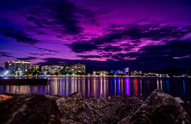
Start in town on the Cairns Esplanade, the long foreshore boardwalk where the city meets Trinity Bay. Its centrepiece is the Cairns Esplanade Lagoon, a free 4,800-square-metre saltwater pool opened in March 2003 and loosely shaped like Queensland. Lifeguards watch it by day, and it is where locals swim when the stinger season closes the beaches.

Out to the Great Barrier Reef
The Great Barrier Reef stretches more than 2,300 kilometres along the Queensland coast, and the day boats to it leave every morning from the Reef Fleet Terminal on the Cairns waterfront. The outer reef is about ninety minutes out and rewards the trip with visibility of twenty metres or more. If you would rather have an island under your feet, Green Island is a true coral cay about forty-five minutes away, with snorkelling straight off the beach and an underwater observatory, while Fitzroy Island, a national park at a similar distance, pairs its coral beaches with rainforest walking tracks. The audio guides for these spots explain how a cay forms, what you are actually looking at underwater and why the dry-season water runs so clear.
Great Barrier Reef
Sprawling coral reef system of thousands of individual reefs, the largest living structure on Earth.
Reef Fleet Terminal
Departure terminal for reef boat trips, built on the site of a World War Two naval wharf.
Green Island
Tiny coral cay of rainforest and white sand ringed by reef, twenty seven kilometers off Cairns.
Fitzroy Island
Rainforest-clad island off Cairns with a coral fringing reef, sheltered coves, and a decommissioned wartime lighthouse.
Up the range to Kuranda
The classic Cairns day out is a loop into the mountains. The Kuranda Scenic Railway, completed in 1891 after workers cut fifteen tunnels and dozens of bridges through the Macalister Range, takes about an hour and three quarters to climb to the village. Along the way it pauses at Barron Falls, a sheer drop that turns into a roaring wall of water in the wet season. Most people ride the train one way and come back on the Skyrail Rainforest Cableway, 7.5 kilometres of gondola gliding over the canopy with two rainforest stations, open since 1995. Listen to the guide on the ascent and the engineering of the line stops being a footnote and becomes the story.
Kuranda Scenic Railway
Heritage rail journey climbing through rainforest gorge past waterfalls and hand-cut tunnels.
Barron Falls
Tiered rainforest cascade over four hundred feet, flow largely tamed by an upstream hydro plant.
Skyrail Rainforest Cableway
Cable car crossing rainforest canopy for seven kilometres, built without a single access road.
North to the Daintree and Cape Tribulation
Follow the Captain Cook Highway north and the rainforest arrives at the sea. The Daintree Rainforest is around 180 million years old, part of the Wet Tropics World Heritage Area and the oldest living rainforest on earth. At Mossman Gorge the Kuku Yalanji people, traditional owners of the Daintree, lead Dreamtime walks from their own centre, and a cruise on the Daintree River is the best place to see saltwater crocodiles from a safe distance. Beyond the river ferry a sealed road runs to Cape Tribulation, where the reef and the rainforest literally touch; a 4WD is only needed for the Bloomfield Track further north. The resort village of Port Douglas, about sixty-five kilometres from Cairns, makes a natural base for this stretch.
Daintree Rainforest
Ancient tropical forest of towering canopy and tangled understorey, older than flowering plants themselves.
Mossman Gorge
Granite gorge in an ancient rainforest, carved by a river through boulders and swimming holes.
Daintree River
Ancient, croc-inhabited river winding through rainforest older than the Amazon, crossed only by cable ferry.
Cape Tribulation
Ancient rainforest running to reef and beach, where Captain Cook's ship nearly wrecked.
Port Douglas
Laid-back tropical harbour town where reef trips and rainforest tours depart side by side.
Waterfalls and crater lakes of the Atherton Tablelands
South-west of the city the land rises to a cool green plateau of dairy farms, crater lakes and waterfalls. Millaa Millaa Falls is one of the most photographed in Queensland, a curtain of water dropping into a swimmable pool. Lake Eacham and Lake Barrine fill ancient volcanic craters, and at dusk the little village of Yungaburra is one of the most reliable places in Australia to spot a platypus. The audio guides here tell the volcanic and rainforest story behind the scenery.
Millaa Millaa Falls
Basalt-shelf cascade folding into a swimmable plunge pool amid rainforest.
Lake Eacham
Volcanic crater lake ringed by rainforest, once home to a rainbowfish found nowhere else on earth.
Lake Barrine
Rainfall-filled volcanic crater lake ringed by rainforest, reached by boat from a lakeside teahouse.
Yungaburra
Two-storey timber pub that grew from a compact railway-era inn into thirty-eight guest rooms.
Beaches north of town
Cairns itself has mudflats rather than a beach, which is why the lagoon exists, but a string of palm-lined beaches begins a short drive north. Palm Cove, about twenty-five kilometres away, is a single shaded beachfront street of restaurants and boutique hotels, and Trinity Beach is a quieter local favourite between the two.
When to go and how to get around
The dry season from May to October brings warm, clear days of 24 to 30°C, the calmest reef water and, in June and July, dwarf minke whale encounters on the outer reef. From November to May it is hot, humid and often spectacular with rain, and box jellyfish make the beaches off-limits without a stinger suit. Cairns Airport is seven kilometres from the centre, buses run north to Palm Cove and up to Kuranda, and a hire car opens up the Tablelands and the Daintree.